

By the time my alarm went off at 3:00 a.m. in Cusco, Ausangate was still only a white shape on the map and in my imagination. Twelve hours later I would be soaking in the Pacchanta hot springs with glacier wind still on my face, trying to process a day that felt more like a compressed high-Andes expedition than a standard day tour. The Ausangate 7 Lakes trek is often marketed as a pretty alternative to Rainbow Mountain, but walking the full circuit from Pacchanta made it clear that this route is about far more than turquoise water. It is an encounter with a living mountain revered as an apu, and with a community that quietly shares its grazing lands with passing hikers.
From Cusco Before Dawn to the First View of Ausangate
The van collected me in the historic center of Cusco at 3:20 a.m., in that foggy hour when the bars are closing but the trekking world is waking up. Most Ausangate 7 Lakes group tours currently schedule pickups between 3:00 and 3:30 a.m. to allow enough time for the three and a half hour drive and a full circuit in daylight. The streets were empty as we threaded out of the city and joined the road that links Cusco with Urcos and Ocongate, the main access corridor toward the Vilcanota range.
It took about one hour to reach Urcos, where the first hints of pink showed behind the hills. Road conditions along this highway were surprisingly good, paved the entire way with only occasional construction slowdowns and speed bumps when passing small towns. We stopped in the district of Ocongate around 5:15 a.m. for a basic breakfast that was included in the tour price: bread rolls, scrambled eggs, jam, hot coffee and coca tea. At this point we were still below 3,600 meters, and the air felt cool but gentle compared to what waited higher up.
After Ocongate, the van left the main highway and followed a narrower paved road that climbed toward Tinke and then Pacchanta. Pavement continued for most of this stretch, but the final approach above Tinke turned into a compacted dirt track with potholes and occasional washboarding. The last 45 minutes were slow and bumpy, the kind of road where a window seat gives both mountain views and a clear look at how remote Pacchanta actually is. Around 6:50 a.m. we crested a small rise and saw Ausangate for the first time, glowing faintly in early light above a basin dotted with stone houses and grazing alpacas.
We rolled into Pacchanta a little after 7:00 a.m. The village sits at roughly 4,300 meters above sea level, higher than many mountain passes elsewhere in the world. The morning sun was out but the air bit through my gloves the moment I stepped down from the van. Here the tour paused for organization: paying the community entry fee at a simple booth, confirming hot springs plans, adjusting layers, and listening to the first briefing from our local guide.
The Exact Circuit: Seven Named Lakes on Ausangate’s Flanks
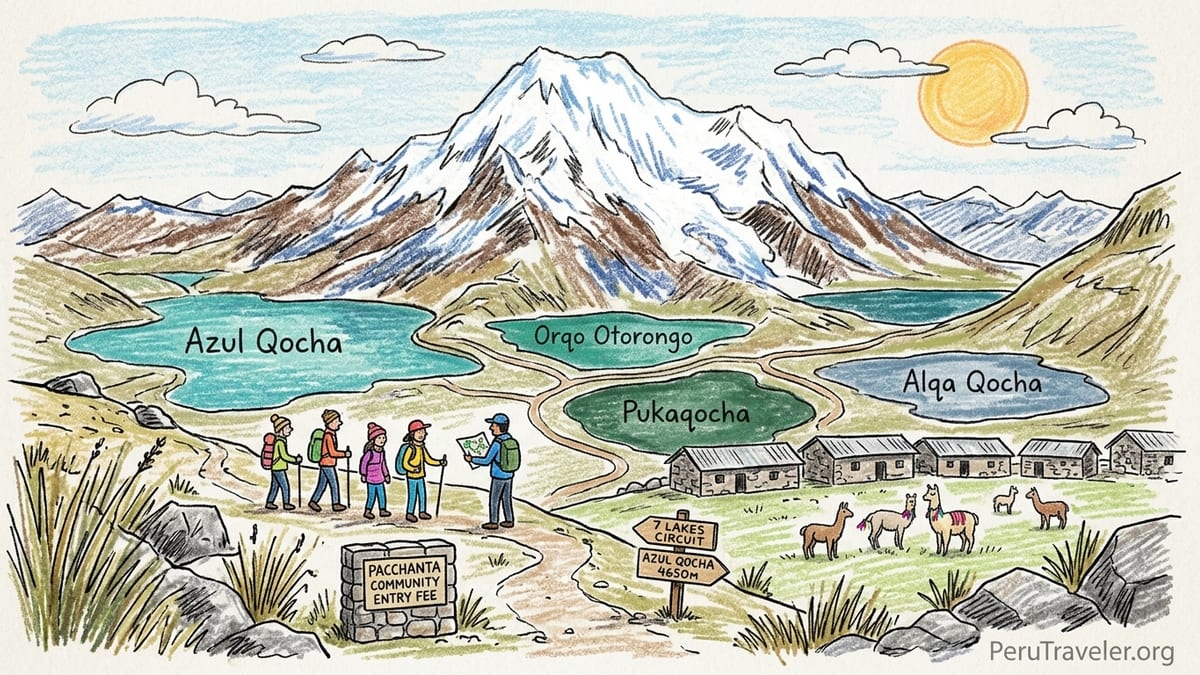
Before starting to walk, our guide spread a laminated map across a wooden table outside a family house and traced our route with a gloved finger. Our clockwise circuit would visit seven distinct lakes: Azul Qocha at the high point, followed by Orqo Otorongo, China Otorongo, Pukaqocha, Alqa Qocha, Qome Qocha and Pataqocha on the descent back toward Pacchanta. He noted that other agencies sometimes vary the order or substitute nearby lagoons, but this would be the exact sequence for our hike that day.
We left Pacchanta at 7:30 a.m. following a dirt track that quickly gave way to a narrow path between stone walls and potato fields. The first section climbed gradually across open puna grassland, gaining about 200 vertical meters in the first hour. Alpaca and sheep grazed within arm’s reach, and small irrigation channels carried cold water down toward the village. The looming white triangle of Ausangate stayed mostly to our right, with lower peaks of the Vilcanota range lining the horizon.
After about 90 minutes and a short steeper push over a grassy shoulder, we reached Azul Qocha, the highest lake on our route at roughly 4,650 meters. The shoreline here is rocky and sparse, with patches of pale grass and ground that crunches underfoot because it is still half-frozen in the shade. We paused for photos and snacks, but the stay was brief because wind at this altitude cut through every layer. Instead of the bright tropical blue often seen in edited photos, the water showed as a deep steel blue with hints of turquoise where a shaft of sun hit near the outlet.
From Azul Qocha the path traversed a hillside and began a series of rolling descents that linked the remaining lakes. Orqo Otorongo and China Otorongo, a pair of neighboring lagoons nestled below moraine slopes, appeared next. Named after the male and female jaguar in Quechua, the two are separated by only a short walk but differ in tone. Orqo Otorongo reflected dark green water with almost black corners where the depth dropped sharply, while China Otorongo glowed lighter jade when clouds parted. Below these, Pukaqocha lived up subtly to its “red lake” name: thin rusty bands along the shallows where minerals colored the sediment, though the main body remained a muted teal. Alqa Qocha, Qome Qocha and Pataqocha completed the chain, each slightly lower and framed by increasingly gentle hills as we angled back toward Pacchanta’s pastures.
Distance, Elevation and What the Difficulty Really Feels Like
Measured by tracker, our full loop from Pacchanta back to the village covered just under 13 kilometers, with about 550 meters of total ascent and similar descent. On paper, many hikers would class this as a moderate hike. The reality at 4,300 to 4,650 meters feels different. Oxygen is thin enough that every incline asks for patience, even for people who consider themselves fit at sea level.
Walking time on our day was a little over five hours of movement, plus around 90 minutes of breaks spread across viewpoints, snack pauses and a simple packed lunch eaten huddled behind a boulder out of the wind. That meant about seven hours total on the trail, returning to Pacchanta close to 2:45 p.m. Several agencies advertise the hike as “easy to moderate,” but my experience aligned more with steady, high-altitude effort. The path itself has only two short steeper climbs, one on the way up to Azul Qocha and another narrow zigzag section above Pukaqocha. Neither involves scrambling, but both feel demanding when your lungs are fighting for breath.
At these elevations, it is important to separate normal exertion from altitude-related symptoms. I felt my heart rate spike quickly on climbs, and my pace naturally slowed. Mild shortness of breath and a sense of heavy legs were constant companions. However, I did not experience headache, nausea or dizziness, which our guide emphasized would be signs of altitude sickness rather than just being tired. Two people in our group reported light headaches near Azul Qocha that eased after descending, drinking more water and taking coca tea at lunch. Anyone coming directly from sea level would likely find this circuit strenuous, and it makes a real difference to spend at least two full days acclimatizing in Cusco or the Sacred Valley beforehand.
Colors, Reflections and Life Around the Lakes
The Ausangate 7 Lakes name suggests uniform turquoise bowls, but what I saw was a more nuanced palette that shifted with every passing cloud. Early in the morning, with the sun still low, Azul Qocha was almost navy blue, its surface broken by ripples driven across by sudden gusts. As we descended and the day grew brighter, Orqo Otorongo and China Otorongo began to reflect patches of glacier and snowfields from the upper reaches of Ausangate. At times the reflection was so sharp that the boundary between shore and sky felt like a thin pencil line.
Pukaqocha surprised me by being less obviously “red” than glossy brochures suggest. Standing close to the shore, I could see ochre staining in the wet rocks and a faint rusty band where mineral-rich water had receded, but the lake itself read as a deep turquoise mixed with hints of brown where wind disturbed sediment. Alqa Qocha, whose name hints at mixed colors, lived up to the description more clearly. From one angle it looked greenish, from another slate blue, with bands of lighter color around the edges where the bottom rose toward the shore. Qome Qocha and Pataqocha lower down were calmer, often mirroring the sky so perfectly that small white clouds drifted across the surface in reverse.
Throughout the circuit we crossed paths with herds of alpaca and llamas that belong not to the tour operators but to Pacchanta families. Many wore simple colored yarn tassels on their ears or necks, a quiet code used by herders to tell animals apart at a distance. Several times our guide asked us to step aside and give wide berth when animals were being driven from one pasture to another, reminding the group that the primary purpose of these lands is grazing, not tourism. The wind played as big a role in the day’s character as the lakes themselves, rising suddenly on exposed ridges and dropping almost completely in sheltered hollows. Temperatures swung from just below freezing in the morning to sun-warmed comfort at midday, then back toward a sharp chill once clouds built over the peaks.
Ausangate as Apu: Culture Without Clichés
As we paused above China Otorongo, our guide, who introduced himself simply as Juan and mentioned he was from a community near Tinke, spoke about Ausangate as an apu. In this part of the Andes, an apu is a mountain considered a powerful protector and a source of water and life. Juan did not describe elaborate rituals for tourists or claim that every rock held a specific story. Instead, he said that for his grandparents, Ausangate was both a landmark they watched for changes in snow cover and a presence they greeted with respect when leaving home or starting field work.
He pointed out how most of the lakes we were visiting existed because Ausangate’s glaciers had carved and filled these high basins. For local communities, the mountain matters less for abstract mysticism and more because it feeds springs and irrigation channels that make agriculture and herding possible in a harsh climate. On certain feast days, people from Pacchanta and neighboring villages do visit nearby shrines or chapels, often carrying flowers or coca leaves, but Juan framed these as moments of gratitude and continuity rather than staged ceremonies. He was careful to separate what he knew from stories he had simply heard from guides who work primarily with foreign groups.
Listening at that altitude, with the mountain’s white wall rising above us, it was easier to understand the idea of an apu as a relationship rather than a legend. Ausangate watched over the valley, influenced weather and water, and in turn demanded caution and humility. That sense of quiet mutual dependence came across more clearly than any dramatic tale might have.
Pacchanta Community: Between Tours and Daily Life
Back in Pacchanta after the loop, the contrast between the commercial rhythm of tours and the slower pulse of village life was impossible to miss. Tour vans lined up along a rough parking strip, their sides plastered with images of bright turquoise water and smiling hikers. A few basic restaurants offered fixed menus to groups, usually a simple soup followed by trout, chicken or omelet with rice and potatoes. Yet walk two minutes away from the parking area and you are immediately in a working community where children walk to school in uniforms, women in layered skirts spin wool while watching over animals, and small plots of potatoes and quinoa press right up against stone walls.
Our guide and driver both emphasized that the community entry fee collected that morning goes directly to Pacchanta’s communal authority, which then allocates funds for trail maintenance, signage, and local projects such as improving the school or maintaining the hot springs area. On my visit the fee was posted clearly on a handwritten sign in soles and matched what other recent visitors had reported, with receipts issued. The amount can change at community meetings, so hikers should expect modest variation from year to year, but the principle remains that this is a locally decided contribution, not a hidden tour-company add-on.
Moving through Pacchanta as a visitor requires a small but important shift in mindset. Paths that look like shortcuts between houses are often family yards. Open fields are working plots where animals can be spooked by sudden movements or drones. Our group was reminded not to photograph people or private homes without asking, and to close gates carefully behind us whenever we crossed a fence line. The day may be sold in Cusco as a scenic outing, but for Pacchanta this is home, grazing land and livelihood layered together.
That mixture of uses is what makes the Ausangate 7 Lakes trek feel very different from a purely touristic destination like Rainbow Mountain. Instead of a single viewpoint built almost entirely around visitor flow, Pacchanta’s landscape is a lived-in environment where tourism is still only one strand of a broader economy based on herding and small-scale agriculture.
Hot Springs, Hidden Costs and Shared vs Private Tours
Most day tours from Cusco include the option to visit Pacchanta’s thermal baths at the end of the hike, but the entrance fee is almost always excluded from the advertised price. On my visit, the community-managed hot springs charged a modest fee in soles per person, paid at a small ticket hut just before the pools. The water felt around the low 30s Celsius, warm enough to ease tired muscles without the scalding heat some travelers might expect. Facilities were simple but clean: several outdoor pools of varying depths, basic changing rooms and toilets, and a small kiosk selling snacks and drinks.
Sliding into the hot water with Ausangate looming in the distance turned out to be one of the day’s most quietly satisfying moments. The earlier wind that had cut across the lakes was largely blocked by low walls around the pools, and the contrast between cool air and warm water helped legs recover from the high-altitude exertion. For me the soak was well worth both the cost and the extra hour it added before heading back to Cusco. Those who chose not to bathe simply rested at nearby tables or browsed a small stand selling woolen hats and gloves woven by local women.
Beyond the hot springs, other costs not included in the tour price typically include the Pacchanta community entry fee and any equipment rental such as trekking poles or extra blankets for the drive. Some operators quote a lower headline price in Cusco and then collect these local payments in cash on the day, so it is worth asking clearly at booking who pays what and when. Having enough small-denomination soles on hand avoids stress when the van stops at payment points or roadside cafes.
My group joined a shared departure in a mid-sized van, which kept costs manageable but limited flexibility. We lingered only briefly at some lakes because the guide had to balance individual photography wishes with overall timing and the need to return to Cusco by evening. Travelers who book a private departure, whether through an agency or by arranging a driver and local guide directly, often gain more control over pace and photo stops. That can mean waiting out a passing cloud to catch better reflections, or spending longer with a herd of alpacas moving across a hillside. The tradeoff is a noticeably higher per-person cost, especially for solo travelers, but for serious photographers or those sensitive to altitude who prefer to walk more slowly, the extra expense can translate into a more comfortable and contemplative day.
Altitude, Safety and Choosing Ausangate Over Other Day Trips
Compared with heavily marketed alternatives like Rainbow Mountain or Humantay Lake, the Ausangate 7 Lakes trek involves similar or even greater altitude but spreads effort across a longer circuit instead of one sustained climb to a single viewpoint. Pacchanta itself starts around 4,300 meters, higher than the trailheads for many other popular hikes in the Cusco region. For some travelers that baseline is the biggest challenge. Stepping out of the van after only a few hours of driving and immediately walking at that elevation is demanding on any body that has not had time to adapt.
During our hike, I monitored my body closely. Normal high-altitude fatigue for me meant breathing harder on inclines, needing more frequent short breaks, and feeling an overall sense of moving in slow motion. What I did not experience were the warning signs our guide described at the start: throbbing headache, nausea, loss of appetite, or confusion. He carried a small oxygen bottle and a radio to contact Pacchanta if anyone deteriorated, but the most useful tools turned out to be pacing, hydration and honesty. One member of the group chose to cut the loop short after Pukaqocha, returning slowly to Pacchanta with an assistant guide when their mild headache did not improve with rest. That option to shorten the route is something many visitors do not realize exists.
We returned to Cusco close to 7:30 p.m., after a dusky drive down from Pacchanta and along the now-familiar road via Ocongate and Urcos. The early departure had made the day feel long, but it also allowed us to walk most of the circuit under decent light and return before the coldest Andean night hours. For travelers debating how to allocate limited days around Cusco, Ausangate’s 7 Lakes offer a more immersive mountain environment and closer contact with a living Andean community than some better-known excursions. Rainbow Mountain delivers a single, dramatic color palette and can feel crowded. Humantay Lake combines a steep climb with beautiful water but sits in a landscape more dominated by tourism infrastructure. In contrast, Ausangate felt like stepping briefly into a broader, less stage-managed world.
None of these options is inherently better; they simply cater to different expectations and tolerances. Those who want a quick climb to a famous viewpoint may prefer Rainbow Mountain. Travelers willing to trade brand-name recognition for a full day of high-Andes walking, quieter trails and time in Pacchanta’s hot springs will likely find the Ausangate 7 Lakes trek a more rewarding use of precious time at altitude.
The Takeaway
Several things about the Ausangate 7 Lakes trek surprised me. The first was how varied the lakes actually were in shape, color and setting, despite the simplified turquoise imagery often used in advertising. Of all of them, Azul Qocha at the high point offered the strongest overall scenery for me, not because it was the brightest, but because of the way it sat in a stark cirque directly below Ausangate, with glacier streaks reflected whenever the wind briefly calmed. Standing there felt as close as you can reasonably get to a high alpine environment on a day trip from Cusco.
The second surprise was how valuable the Pacchanta hot springs turned out to be. I had half expected a crowded, overly commercial setup. Instead, I found modest facilities run by the community, water warm enough to soothe muscles without feeling oppressive, and just enough time to unwind while still watching clouds drift around the summit of Ausangate. After several hours of walking at high altitude, the simple act of soaking feet and legs while sharing quiet conversation with other hikers felt worth every sol of the entrance fee.
The early departure from Cusco undeniably affects comfort. A 3:00 a.m. wake-up is harsh, particularly if you have not slept well or are coming off other early starts for Machu Picchu or Sacred Valley tours. Yet for this particular trip, the schedule makes functional sense. It minimizes sun exposure during the hardest climbs, provides a safety margin in case weather changes or someone in the group slows down, and still gets you back to Cusco in time for a proper dinner. For those who really dislike early mornings, an alternative is to spend the night before in Pacchanta at a simple guesthouse, but that requires arranging private transport and more independent logistics.
Looking back, if I had to choose between repeating this hike or booking another classic but crowded excursion from Cusco, I would pick Ausangate again. The route from Pacchanta to Azul Qocha and back past Orqo Otorongo, China Otorongo, Pukaqocha, Alqa Qocha, Qome Qocha and Pataqocha provided a rare combination of serious mountain scenery, cultural context and quiet stretches of trail. It asked more from my lungs and legs than glossy brochures imply, but gave much more in return. For travelers willing to respect the altitude, carry enough layers, and remember that Pacchanta is someone’s home before it is anyone’s tour stop, the Ausangate 7 Lakes trek can be the high point of a Cusco itinerary in more ways than one.
FAQ
Q1. How long does the Ausangate 7 Lakes trek from Pacchanta take in total?
The full day from Cusco usually runs about 16 hours door to door, with three and a half hours of driving each way and around seven hours allocated for hiking, breaks and hot springs.
Q2. What is the highest elevation reached on the 7 Lakes circuit?
The highest point on the route described here is near Azul Qocha, at roughly 4,650 meters above sea level, with Pacchanta itself sitting around 4,300 meters.
Q3. How difficult is the hike compared with Rainbow Mountain or Humantay Lake?
The distance is longer but the inclines are more gradual than Rainbow Mountain, and effort is spread across a loop instead of one steep climb, although similar altitude makes it feel strenuous.
Q4. Do I need special permits to hike the Ausangate 7 Lakes from Pacchanta?
No national park permit is required, but you do pay a locally set Pacchanta community entry fee on arrival, which helps fund trail maintenance and local projects.
Q5. Are the Pacchanta hot springs worth visiting after the trek?
For most hikers the hot springs are a highlight, offering simple but clean pools with warm water and direct views of Ausangate, which can greatly ease post-hike fatigue.
Q6. What extra costs should I budget for beyond the advertised tour price?
Plan for the Pacchanta community entry fee, hot springs entrance, optional equipment rental like trekking poles, and any snacks or drinks not included with the group meals.
Q7. Can I do the 7 Lakes trek without a guided tour from Cusco?
Experienced hikers can hire a private driver to Pacchanta and walk the signed circuit independently, but arranging transport, acclimatization and emergency plans then becomes your responsibility.
Q8. What clothing and gear are essential for this high-altitude day hike?
Layered clothing, a warm hat and gloves, waterproof jacket, sturdy hiking shoes, sun protection, at least two liters of water and trekking poles are strongly recommended.
Q9. How many lakes will I actually see, and can the names vary?
The standard circuit visits seven distinct glacial lakes, though the exact order and even which lagoons are included can vary slightly between operators and guides.
Q10. Is the Ausangate 7 Lakes trek a better use of a day than Rainbow Mountain?
For travelers seeking quieter trails, varied scenery and time in a real Andean community, Ausangate 7 Lakes often feels more rewarding than the single crowded viewpoint at Rainbow Mountain.